By Steve Bell, Lake Watch columnist
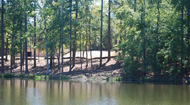
In early June of 2019, Lake Watch noticed what appeared to be “excessive” shoreline clearing within the 75’buffer on Lot 5, Key Island Cove on Lake Murray. This lot is part of a parcel known as the “Byrum Tract”. The tract was approved for development in an order by the Federal Energy Regulatory Commission (FERC) on January 29th 2009. Thirteen other tracts were approved in the same order. Lake Watch, SCDNR, US Fish and Wildlife, SCPRT, SC Wildlife Federal, the Lake Murray Association and numerous other stakeholders intervened in opposition to development on these tracts because of the high natural resources values and the fact that Lake Murray is already overdeveloped. In spite of the strong opposition, FERC officials approved the sale of these project lands, but included additional measures to better protect the public and natural resources at these tracts. The Commission ordered:
1-“ SCE&G shall establish a 50-foot natural buffer around each identified environmentally sensitive area (ESA) adjacent to each of the 14 parcels that are approved for sale, and mark each natural buffer and the ESA with appropriate markers.”
2-“ SCE&G shall establish a 25-foot natural buffer zone above the 360-foot-high water contour in areas without ESAs. This buffer zone shall contain an access pathway to the boat docks for homeowners and as needed shall contain a pathway along the shoreline for general public use. The remaining 50 feet of the 75-foot buffer zone shall be managed under SCE&G’s current permit policy and requirements.”
Lake Watch met with Mr. Billy Chastain, Dominion’s lake manager, at lot 5 and discussed concerns about excessive clearing. Mr. Chastain claimed that the understory was composed primarily of small pine saplings which the owner was allowed to clear. Lake Watch questioned why the adjacent lot was so heavily wooded down to the water’s edge with a variety of natural shrubs and trees, while lot 5 had mostly pine saplings and larger trees. Based on the additional clearing restrictions, there should have been at least a 50 ft. undisturbed area, above the ESA’s and a 25’ undisturbed area landward of the water’s edge. In addition, Lake Watch questioned why the back property owner was allowed to post the buffer zone with “Keep Out” signs since buffer zones are public recreation areas.
On September 5, 2019, Lake Watch filed a complaint with the FERC alleging that excessive clearing had occurred at Lot 5, Key Island Cove and at the “ Moore” tract off Plantation Rd in Newberry County. The Lake Murray Association, SC Wildlife Federation, and American Rivers followed with letters of concern.
In response to Lake Watch’s allegations, Dominion explained in an Oct. 2, 2019 letter to the FERC that, “DESC agrees that the 25-foot and 50-foot natural buffer zones on those developed or partially developed parcels that have been sold require revegetation in order to bring them into full compliance with the FERC Order. To that end, DESC is in the process of contacting the owners to notify them that these areas will be brought into full compliance with the FERC Order.”
Based on its response, DESC either ignored the FERC order or was not aware of it due to a change in lake management personnel. And while DESC appears to be taking action to resolve the violations, the question remains whether these areas will ever return to their undisturbed state as required by the federal order. The project’s new license, when implemented, will be even more restrictive, banning any clearing within the 75’ ft buffer except for a meandering path to homeowners’ docks. The question remains whether DESC is going to take the FERC orders seriously. If not, DNR, US Fish and Wildlife, and groups like Lake Watch will need to step up to the plate and provide monitoring and oversight of these last remaining undeveloped tracts.
Steve Bell is President of Lake Murray Watch and can be reached at lakemurraywatch.com

Lake Watch files a complaint about excessive clearing on a lot in the Key Island Cove development. The photo shows the cleared area next to the adjacent undisturbed lot. The FERC order prohibited any clearing within 50 ft. of environmentally sensitive areas and within a 25’ area above the high watermark.


